Perhaps the biggest change in Bushnell Park since it was established in 1854 is the disappearance of the Park River, one of its chief features. This river once entered Bushnell Park near the State Armory, and meandered along the Park’s north side, where Asylum, Ford and Jewell Streets now edge the Park. At the end of Bushnell Park, it made a sharp turn near Pulaski Circle, passing under Main Street, on its way to the Connecticut River. The Main Street bridge is still visible today.

Of the five bridges that once crossed the Park, only one remains visible, at Trinity and Ford Streets, where a brownstone bridge crossed the river at the Soldiers and Sailors Memorial Arch.
Where did the Park River go and why did it disappear? The answers to those questions lie in history and nature.
When Thomas Hooker and his band of settlers arrived in Hartford in 1636, they stopped where the “Little River” emptied into the Connecticut. That was Dutch Point, an area named after the Dutch traders led by Adraen Block (Block Island) who sailed up the Connecticut and purchased the land from the Pequots in 1623.

Almost immediately people saw the “Little River” as a source of energy to power their mills and factories, while the “Great River” was used for transportation. Over the years, the Park River became dotted with mills, factories and tenements. Factories like the Pratt and Whitney Machine Parts Co. which began operating in the mid-1800s, and Col. Albert Pope’s bicycle and automobile factory which opened later emptied their wastes into the river. The Mill River, as it had become known, was turning murky from industrial wastes.
By the 1850s, when City Park (later renamed Bushnell Park) was being proposed, the “Little” or “Hog River”, as it was aptly known because pigs once fed in a pasture along its banks, was certainly “smelling up” to its name.

A major reason that Horace Bushnell wanted to create a public park in the center of the city was to clean up the river. He wanted to get rid of the tanneries, tenements and garbage dumps and create a beautiful scenic place where factory workers, bankers, and mothers with their children could come and enjoy themselves. He also wanted to create a pleasing first impression of Hartford for travelers arriving by train from the South.
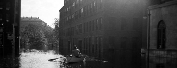
Nature, specifically seasonal flooding, combined with growing pollution of the river, was the other major reason for the river’s disappearance. Each spring, when the Connecticut overflowed its banks, the Park River would back up, blocked by the high water from completing its journey into the Connecticut. As a result, it would routinely flood low lying lands which included Bushnell Park.
Some years were worse than others.
1936-1938
The great flood of 1936 inundated all of Bushnell Park and much of Hartford under several feet of water.

Property damage was in the hundreds of millions of dollars; homes and lives were lost. Then it happened again in 1938. The hurricane that devastated the Rhode Island beaches also hit Hartford dead-on. While the flooding wasn’t quite as bad as two years before, this was the straw that broke the camel’s back. The city fathers, determined to protect their real estate investments from anything like this happening again, decided to seek help from the federal government. In 1940, the Army Corps of Engineers began work on one of the largest public works projects in New England.
Flood control
The Army Corps of Engineers came up with a plan that would contain the

main branch of the Park River in a huge underground conduit or tunnel. During much of the 1940s, they literally changed the course of the river, burying it in a huge concrete box-shaped tunnel, 30 feet high and 45 feet wide. The conduit runs straight as an arrow through the center of the park underneath the pump house, Pulaski Circle and Main Street, under the Hartford Public Library and the Conland-Whitehead Highway, finally arriving at the Connecticut River.
The Bushnell Park section of the flood control project was completed in 1949. Later sections were completed after the major flood of 1955, with the entire project ultimately completed in the early 1980s. In all, the conduit system, which encloses both the North and South branches of the Park River, is more than nine miles long and cost more than $100 million.
But part of the Park River still remains above ground. The North Branch enters Hartford in the city’s West End, running through the University of Hartford campus. It’s possible to launch your kayak or canoe there and paddle through a wooded wilderness for about six miles, as the gently flowing river passes behind public housing projects and private estates fronting on Scarborough Street. Here, the river is shaded by giant oak, elm, maple and other trees. Red-tailed hawks and dozens of varieties of birds have been spotted in this area, as well as deer, raccoons, skunks, and rats, foraging for food along the bank. As you approach Farmington Avenue, your journey will come to an end because this is where the river enters the tunnel–just a few hundred feet from the Mark Twain house.